
Capture every locate with RTK accuracy, a patented LocateIQ™ score, and complete field documentation — so every future locate starts with confidence, not guesswork.
 Radiodetection
 EOS Tools
 Trimble
 Juniper
 Leica
Leica
 Emlid
Radiodetection
EOS Tools
Trimble
Juniper
Leica
Emlid
Emlid
Radiodetection
EOS Tools
Trimble
Juniper
Leica
Emlid
Everything you need to capture, manage, and sync utility survey data with centimeter-level accuracy.
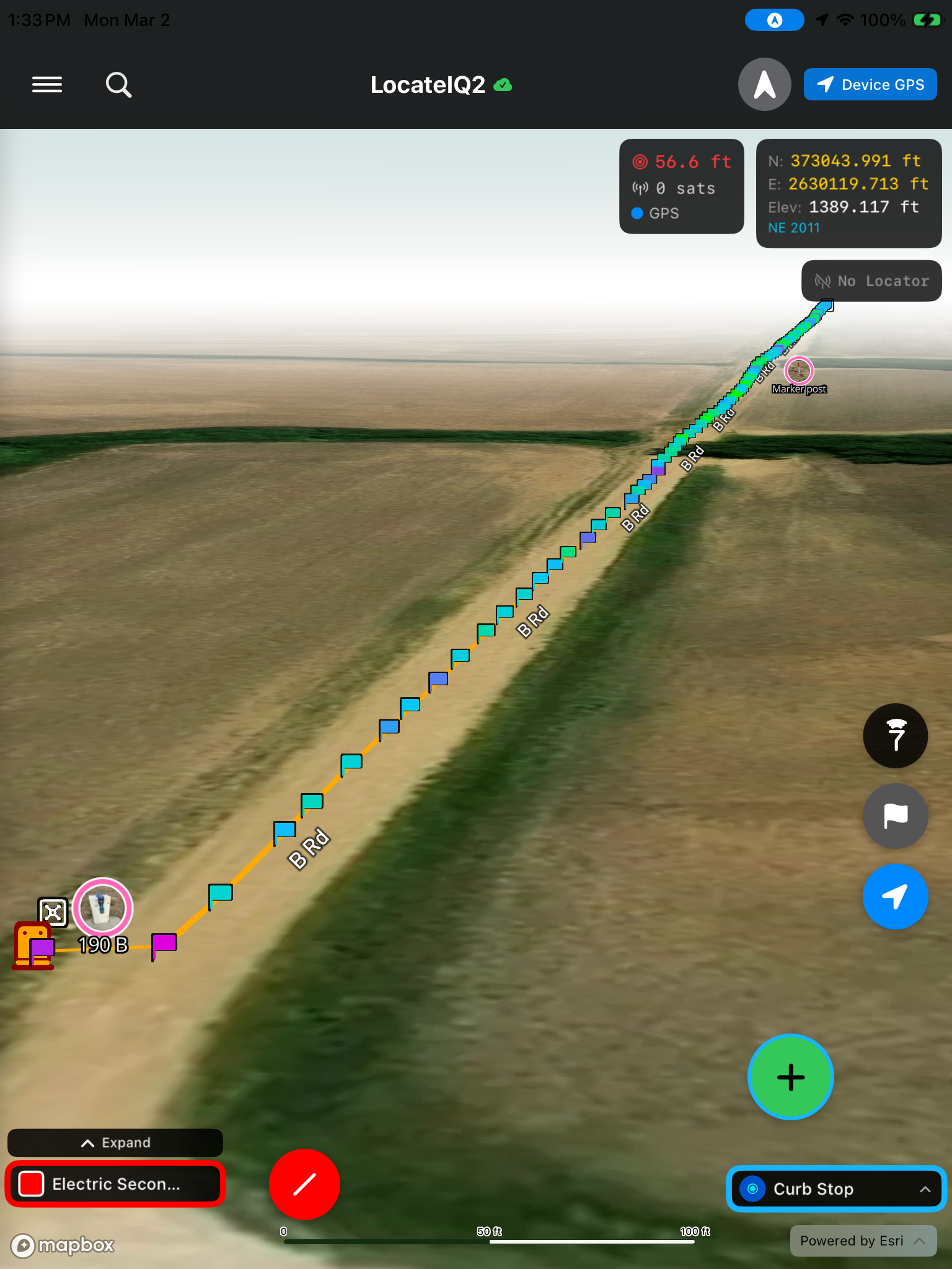
Dynamic circular field detection algorithms designed to detect bleedoff and distorted EMF fields. Trust now. Relocate effortlessly forever.
Learn more →
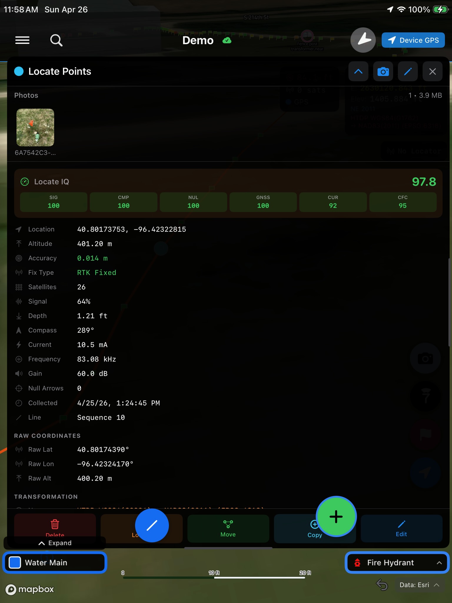
Per-point scoring: green = high confidence, yellow = caution, red = signal distortion / bleedoff
Connect external GNSS receivers via Bluetooth for centimeter-level accuracy with real-time NTRIP corrections.
Instant connections for GNSS survey data logging with a utility locator and RTK correction streaming.
Two-way synchronization with ArcGIS Online feature services for points, lines, and photo attachments.
Coordinate controls and projection settings for real location accuracy.
Interactive 3D mapping with Mapbox and Esri basemaps, real-time coordinate display in multiple projections.
Optimized workflow for RTK relocating captured lines with precision and accuracy. Live bearing and distance to every previously-located feature in your project.
Each point carries a complete forensic record: live RTK fix type, satellite count, accuracy, depth, signal/current/frequency from the locator, and full transformation metadata — written automatically as you survey.
When it's time to relocate, every field that mattered when the line was buried is right there with you in the field.
Watch a real survey session — from connecting a GNSS receiver to syncing data with ArcGIS.
Pair your GNSS/RTK device via Bluetooth. LocateIQ handles NTRIP corrections automatically for centimeter accuracy.
Drop points, trace utility lines, capture photos. Everything is geo-tagged with precise coordinates and metadata.
One-tap sync pushes points, lines, and photos to Subsurface Maps or ArcGIS Online. Two-way sync keeps everything current.
From local-only mapping to full cloud integration with Subsurface Maps or ArcGIS.
Local data • No sign-in required
+ $20/mo per additional user · Subsurface Maps subscription included
*requires an ArcGIS subscription (billed separately by Esri)
Subsurface Maps is the industry-leading cloud platform for underground utility mapping. LocateIQ brings its full power to your field workflow.
Subsurface Maps is a cloud-based GIS platform purpose-built for utility locators, engineers, and municipalities. It stores your underground utility data — lines, points, photos, and attributes — in the cloud where your entire team can access it from any device. With LocateIQ, you get the best of both worlds: precision field data collection with LocateIQ's scoring and survey tools, seamlessly synced to your Subsurface Maps account.
Sign in with your existing account to unlock LocateIQ features on your maps.
Sign in with Subsurface MapsContact us to get set up with a Subsurface Maps account and start mapping underground utilities in the cloud.
Contact Us to Get StartedTell us a bit about your team and we'll get you set up. Prefer to dive in? Pick a plan above to create your account now.
Get started with LocateIQ — whether you use Subsurface Maps, ArcGIS, or just need local mapping.